London's Tree Map
Explore a collection of over 1.1 Million Public Realm Trees in London.
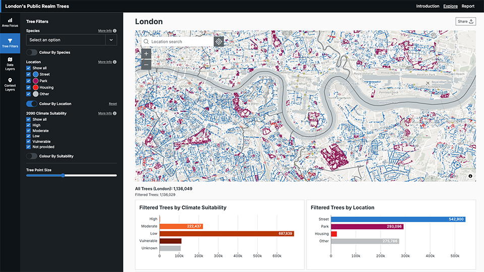
Explore The Tree DataDiscover London’s Trees
The London Tree Map shows where more than 1.1 million trees are in streets, parks, and other public spaces across the city. For each tree, you can see its species or genus (if known) and a climate suitability score. This score shows how well that type of tree is expected to cope with London’s future climate in the year 2090.
What can you do?
Explore Your Area
Look up the trees on your street, in your local park, or across your borough.Filter by Tree Type
Choose to see only street trees, park trees, or other public trees.Add Context with Overlays
Turn on extra layers like tree canopy cover or the Index of Multiple Deprivation to see how trees relate to social and environmental factors.Download the Data
Get the full dataset from the London Datastore for research, planning, or community projects.
About the Data
The map includes three main types of information:
Public Tree Inventory
Data from all 32 London boroughs, The City of London, Transport for London, Royal Parks, the London Legacy Development Corporation (Queen Elizabeth Olympic Park), and Quintain (Wembley Park). Note: Some records do not have exact map locations, so there are gaps on the map.
Climate Suitability Scores
From the report Future Climate Suitability of London’s Public Realm Trees. These scores show how well each species or genus is expected to cope with London’s climate in 2090.
Context Layers (Coming soon!)
London Canopy Cover Map (2024) – Shows how much of London is covered by tree canopy.
Index of Multiple Deprivation (IMD) – Shows levels of deprivation at local area level.
Start Exploring
Find the trees near you and learn more about London’s public trees
- Over 1.1 million public realm trees
- Filter trees by location and climate suitability
- Data for your Borough, Ward or LSOA
- Google Street View integration